
Climbing the highest point in Devon
 It’s a glorious, sunny, if windy day, and there before us stretches Yes Tor and along a ridge to the south, High Willhays, Devon’s highest point.
How to find Devon’s highest point
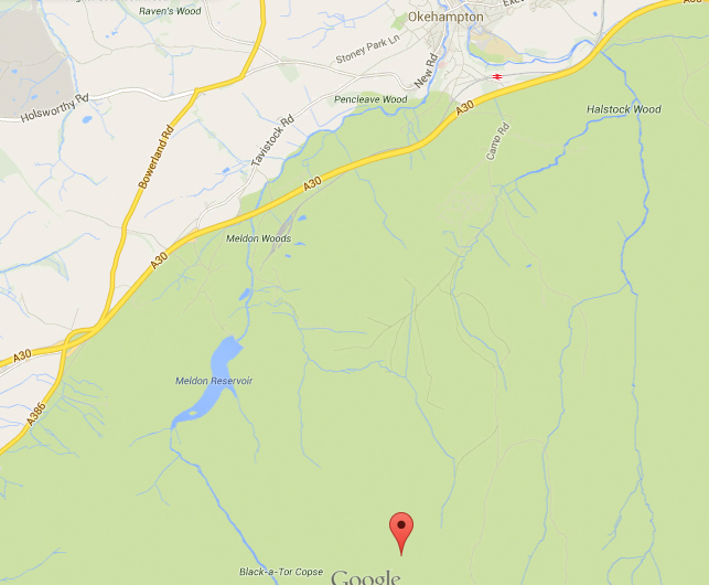
- High Willhays is an hour or so’s hike from a free car park on the north of Meldon Reservoir which is well signposted when you exit the A30 just west of Okehampton.
- It’s south east of the car park and up and over a steep hill
- At 621m it’s the south of England’s highest point, only 2 metres higher than Yes Tor just to the north.
- It’s the highest point in the UK south of the Brecon Beacons in Wales
- It’s the 8th highest county point in England
 The story behind the walk
We’re facing a long drive back from Cornwall on a bank holiday and the prospect of only a lunch break in a service station to break the tedium of sitting in a traffic jam.
I suggest we look for a highest point along the way and a weak mobile signal coughs up three more or less on the route back.
By far the most enticing is Devon, not only the highest point in the south of England but also within one of my favourite places in the world, Dartmoor.
It’s a real marker on our attempt to climb the highest point in each county in England.
With Google Maps refusing to aid navigation planning with the West Country’s dodgy signal, we rely on a road map and the knowledge that there’s a car park on the north side of the Meldon Reservoir that mercifully is well signposted.
In the car park, I canvas opinion from the mix of dog walkers and well kitted out hikers as to the right direction and likely walk time and point my compass in the right direction as the barren moor stretches out majestically before us.
It’s a fair distance for small legs, a good hour and a half, with a sharp climb over one steep hill to get a view of High Willhays and Yes Tor to its north.
There’s a path that climbs up the slope at an angle but with time pressing and the advantage of a dry day we go route one and straight up and over.
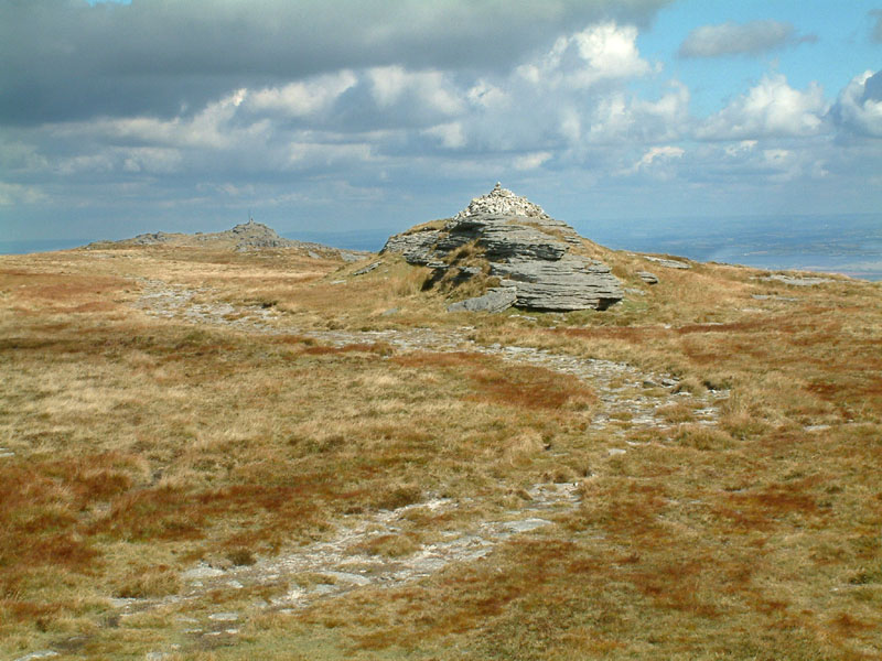
As we reach the summit of the first hill, the glorious sight of the tors stretch before us with yet more tors and steep valleys further into the distance.
The wind is strong as we climb but it’s a welcome relief from the sun and heat of the climb.
Thankfully there’s a relatively small dip until we begin the next climb, so we don’t lose too much height, although if you go too far north there’s a steep valley with a river cutting through the landscape.
In front of us are marker posts indicating the military firing range zone, but there’s no activity today. Note: always check the website to find out which days it’s in use!
As we reach the top it gets steeper with an enjoyable scramble over the rocks to reveal a false summit and more scrambling and rock-climbing for the boys.
At the top are a couple of buildings and what looks like a signalling post alongside the traditional collection of weather-worn and seemingly gravity defying collection of rocks at the top.
We sit down for lunch sheltering from the wind among a group of rocks.
Taking in the magnificent views across Dartmoor, I’m puzzled as to the Tor to the south at a similar height. From the map, I know there’s only two metres difference between Yes Tor and High Willhays and sure enough we’re on the wrong one when I check with a fellow group of hikers far better equipped with a GPS device.
It’s a deceptively long walk to a pyramid-shaped pile of rocks that marks the actual highest point and the photo opportunity to mark the boy’s conquest of south England’s highest point and in the top 10 overall.
A molehill in comparison to other peaks even in the UK, but I’m proud of the boys for making the long trek and they seem excited by the idea of breaking into the top 10.
We walk back in the sunshine with tiring legs and back to the reservoir and its car park and reflect on what could have been one of the dullest of days turned into one of the most special with a little spontaneity and a little determination to continue on with our set of climbs.
Teddy rating:
Views – 4/5 teddies. Simply glorious on a clear day, even more so after the steep climb.
Ascent – 4/5 teddies. Steep climbs, scrambling, streams cutting through the valleys and a rock climb at the top.
Overall rating – 4 teddies

Recent Comments